
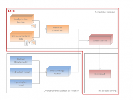
The flood risk tool LATIS is developed by Flanders Hydraulics and University of Ghent for assessing the consequences of floods. This GIS-based tool calculates economic risk (expressed in euro/year) as well as human loss (expressed in casualties/year). The methodology defines flood risk as the product of the probability of a flood event and the damage caused by that event. The damage is a function of the water depth and the maximal damage, which is dependent on the land use of the flooded area and the socio-economic context.
Several steps are required to calculate damage and risk:
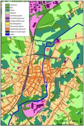
A crucial parameter in flood risk calculations is a correct base map of the land use, since some land use classes (e.g. buildings) can cause more than 1000 times the damage than other classes (e.g. pastures). LATIS uses a very detailed land use map (on parcel level) where the exact location of buildings (both residential and industrial), roads and special constructions is taken into account. Based on this land use information and socio-economic data, it is possible to produce a maximum damage map. This map indicates the cost value for a virtual scenario in which everything is destroyed by a (flood) event.
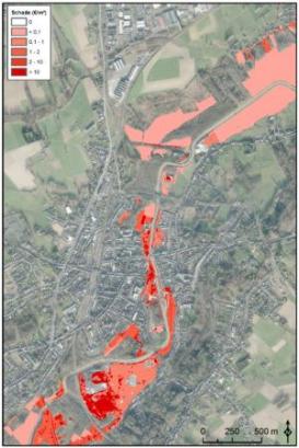
The next step combines the maximum damage map with the different flood maps to create maps of real flood damage. Floods rarely lead to total destruction. The extent of damage depends on water depth because all land use categories have different relationships between the amount of damage that occurs and water depth. These relationships are defined by damage functions. The damage functions used were adapted from international (especially neighbouring countries like United Kingdom and The Netherlands) literature.
In a final step, different damage maps for several return periods can be combined into one risk map.
Besides material damage, floods cause human casualties due to the instability of people in rapidly flowing water and from building collapse. In addition to water depth, also rise velocity and flow velocity are taken into account for the calculation of the number of victims.
In the past years, LATIS was used for several studies in Flanders, varying from assessments of the impact of different climate change scenarios on flood risk to studies on coastal defence alternatives within the framework of the Integrated Masterplan for Flanders’ Coastal Safety. LATIS continues to play an important role in fulfilling the requirements of the European Flood Directive (EU Commission, 2007).
LATIS is built on Microsoft.NET technology in combination with the raster GIS package Idrisi (Clark Labs). The user interface of the application and algorithm of the model were implemented in the programming language C#.NET.